Registration Now Open
Secure your Network X Americas ticket today! Book before February 1st 2026 and take advantage of our introductory rates.
May 18-20, 2026 - Dallas, Texas
Network X Americas
INTELLIGENT NETWORK, INFINITE POSSIBILITIES
The telecom industry is at a pivotal moment. AI is transforming networks into intelligent ecosystems, unlocking infinite possibilities for growth, efficiency, and innovation. Join us for Network X Americas and be part of the conversation that will define the next decade of connectivity.
INTELLIGENT NETWORK, INFINITE POSSIBILITIES
In a world where connectivity powers every sector, networks are becoming intelligence ecosystems. The boundaries between connectivity technologies are dissolving, giving rise to unified, adaptive platforms powered by automation and real-time intelligence.
Network X Americas is where the convergence of mobile, fixed, Wi-Fi, and satellite connectivity meets the transformative power of artificial intelligence. Join us for the 2026 iteration of the event to explore new ideas, learn and engage with industry leaders, and witness the future of connectivity unfold.
WHO TO EXPECT AT NETWORK X AMERICAS 2026?
Connect with the key players driving the North American telecoms ecosystem.
Expect to meet leading service providers, solution vendors, and innovators shaping the future of connectivity. From telecom operators advancing 5G, fibre, satellite, and next-gen Wi-Fi to strategists pioneering AI-driven automation and shared spectrum innovation, the event brings together the brightest minds in the industry.
+
UNIQUE OPERATOR COMPANIES
%
DECISION MAKERS/VIP
+
US STATES REPRESENTATION
+
ATTENDEES
+
SPEAKERS
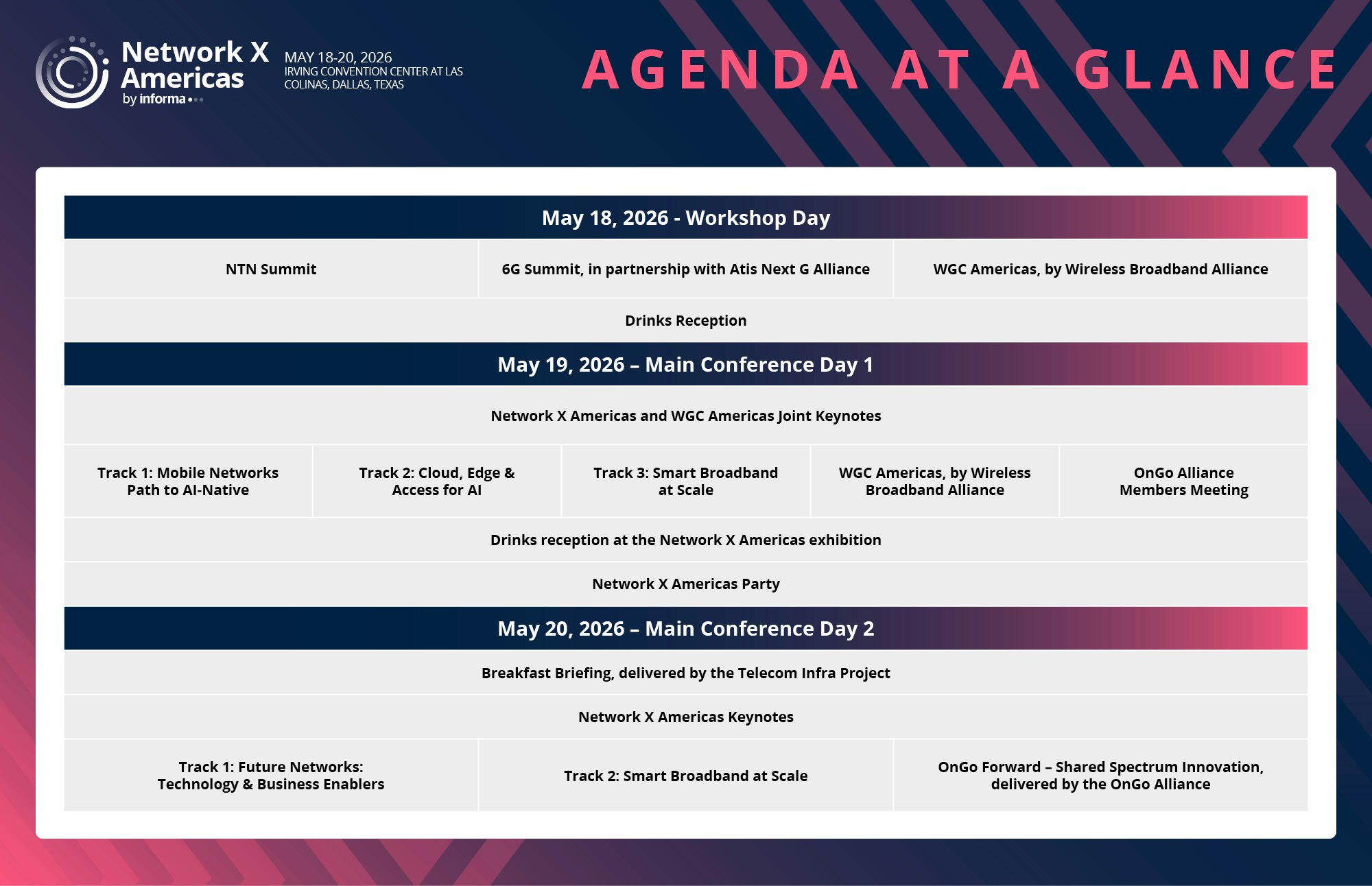
2026 PROGRAM AT A GLANCE
The 2026 agenda will shape telecom innovation and industry evolution. Keynotes feature influential voices sharing strategies for network evolution, AI-native infrastructure, and monetization.
Explore AI-powered automation, edge inferencing, fibre evolution, and monetization models across six tracks: Mobile Networks Path to AI-Native, Smart Broadband at Scale, Future Networks: Technology & Business Enablers, Cloud Edge and Access for AI, 6G, NTN.
Unlock unparalleled access to multiple industry-leading events in one place. Co-located with the Wireless Broadband Alliance’s WGC Americas, OnGo Alliances’ OnGo Forward – Shared Spectrum Innovation, and featuring an exclusive Breakfast Briefing delivered by Telecom Infra Project, Network X Americas is an all-in-one experience.
Join multiple networking activities and receptions designed to connect you with the right people and spark meaningful conversations.
UNVEILING THE 2026 CONTENT THEMES
WHERE AUTHENTIC DIALOGUE MEETS STRATEGIC OPPORTUNITY!
Network X Americas delivers an immersive experience designed to redefine connection and collaboration, being intimate enough to foster both scheduled meetings and spontaneous conversations. Attendees consistently praise Network X Americas on the exceptional seniority of participants and how this creates an environment where every interaction is meaningful, every discussion insightful, and every connection a potential game-changer.
MORNING BREWS & BUSINESS CUES
THREE-MINUTE MINGLES
SPEAKER SPOTLIGHT SESSIONS
VIP ROUNDTABLES
NETWORKING SOCIALS
SPEAKER & VIP LOUNGE
WIRELESS GLOBAL AMERICAS AT NETWORK X AMERICAS
In 2026, Network X Americas will once again deliver a prestigious experience in partnership with Wireless Global Congress Americas. This two-day event will bring together leaders and experts from across the Wi-Fi ecosystem, alongside network operators, enterprises, and city representatives to share knowledge, learn, network, and drive business forward.
WGC Americas will offer unparalleled opportunities to explore how Wi-Fi can transform businesses, discover the latest advancements in Wi-Fi technology, and understand how these innovations integrate with other wireless solutions. Attendees will gain insights into technical standards, real-world trials and deployments, best practices, and industry guidelines, ensuring every conversation sparks ideas and every session delivers actionable value.
6G SUMMIT IN PARTNERSHIP WITH ATIS NEXT G ALLIANCE
Dive into the cutting-edge world of 6G, where ultra-fast speeds, near-zero latency, and transformative technologies like AI, quantum computing, and integrated networks converge.
From ground-breaking research to real-world applications, the 6G Summit will reveal how this next-generation technology can unlock new revenue streams, transform industries, and create tangible value for businesses and communities alike.
YOUR GATEWAY TO GREAT CONVERSATIONS
Vital insights from Network X Americas 2025 from some of the biggest names in the industry
RELIVE THE BEST MOMENTS FROM 2025
Network X Americas 2025 brought together telecom leaders, operators, and technology innovators to explore the future of AI-native networks, 5G evolution, and next-generation connectivity solutions. The three-day event featured cutting-edge insights on network transformation, cloud-edge integration, and the path toward 6G technologies that will shape the telecommunications landscape.
FIRESIDE CHAT WITH DAN THYGESEN: UNLOCK 5G WITH NETWORK APIS
T-Mobile's Dan Thygesen, SVP Product Partnerships & Growth. GM - Wholesale & Innovation MVNx & Partner Brands at T-Mobile joinsed Chetan Sharma, CEO at Chetan Sharma Consulting for a fireside chat exploring how network APIs can unlock 5G's full potential for enhanced services and innovation opportunities.
YIGAL ELBAZ: DELIVERING A ROBUST, CONVERGED, NATIONWIDE NETWORK
Yigal Elbaz, SVP, Technology & Network Services, Network Chief Technology Officer at AT&T discusses expanding fiber infrastructure, leveraging cutting-edge technologies for enhanced customer experience, and driving network innovation through FWA growth, private networks, and open APIs to deliver a robust nationwide converged network.
Step Into Leadership: Elevate Your Impact in Tech
A hands-on leadership accelerator designed for telecoms executives and emerging leaders ready to lead with confidence.
In the fast-paced world of telecoms, leadership isn’t just about mastering systems. It’s about inspiring people, driving clarity, and navigating complexity with confidence. The Leadership Essentials Acceleration Program (LEAP) is your opportunity to sharpen the skills that matter most. In just three hours, you’ll gain actionable insights, build a personalized growth plan, and walk away ready to lead teams, not just projects, with influence and impact.
2025 SPONSORS AND EXHIBITORS


